

Published in Emergence
May 2024
It feels like walking in snow, one step forward and a half step back, the same unsteady shift and slide. But rather than snow, beneath my feet are millions of tonnes of sand. This powdered quartz mountain moves – not just its skin, displaced by every step, but its whole enormous mass, by up to thirty feet a year, perhaps a tenth of an inch a day, inexorably rolling east. That might sound slow compared with the speed of a human life, but so does sea level rise. So do melting glaciers.
To my left is a vast freshwater lagoon, cold and grey, flecked with icebergs, beyond which lies the mainland shore of Lithuania. To my right is the roar and thunder of the Baltic Sea. Ahead, beyond the Grobštas Strict Nature Reserve and the Valley of Death, is the Russian exclave of Kaliningrad, made unreachable now by war at the other end of Europe. And behind, framed by brutalist runes, is a sundial comprised of a two-hundred-tonne granite obelisk, an occult-looking monument to this country’s pagan origins. A memorial to the passing of time is deeply fitting here. But in these grey winter days, when the sun hasn’t come out for a week, time – unlike the sand – appears to have stalled.
This is the giant Parnidis Dune halfway down the Curonian Spit, a sixty-mile-long sandbar that runs alongside the Baltic coast from Lithuania in the north to the Russian Federation in the south. A UNESCO world heritage site, it is ecologically and culturally unique, formed from enormous dunes that rose from the sea five thousand years ago. Legend says that it was created by a giantess called Neringa. This mythical land reclamation scheme was her response to the violent storms stirred up in the Baltic Sea by Naglis, a dragon whose romantic advances she had spurned – a tidal defense that saved the coast from catastrophic flooding. The term ‘Curonian Spit’ was invented by geologists; Lithuanians call it Neringa, after its creator.
As the years went by, the naked sand was covered by birch, oak, and pine, and the narrow strip of forest filled with birds and game. Settled by Neolithic tribes who left standing stones and pottery shards, Neringa’s population grew through the Dark and Middle Ages. While the rest of Europe was Christianised, the people of the Baltic coast and its densely forested hinterland held out as a redoubt of paganism, resisting Catholicism to the west and Orthodoxy to the east. In the twelfth century, Pope Celestine III gave his blessing to the Northern Crusades, and armies of Christian knights, spearheaded by the Teutonic Order, launched a series of campaigns against recalcitrant tribes of Curonians, Lithuanians, Estonians, Latgalians, Livonians, and other worshippers of the old gods. The conquest was bloody and protracted. Only after two centuries of warfare did the Grand Duchy of Lithuania, Europe’s last pagan state, finally submit to the cross in 1387.
Christianisation, and union with Poland, catalysed metastatic growth. The combined Polish-Lithuanian state, at its greatest extent, was the largest on the Continent, encompassing much of modern Ukraine and stretching from the Baltic to the Black Sea. But outside attack and internal collapse reduced it to a stub. By the end of the eighteenth century most of Lithuania had fallen under Russian control, while its coast – including the Curonian Spit – was ruled by Prussian descendants of the Teutonic crusaders.
Throughout this time, on sacred hills and in oak groves, out of the Church’s sight, people in the countryside quietly continued their old beliefs, worshipping Dievas the creator and Perkūnas the thunder god even as they prayed to Jesus Christ. In the eighteenth century, Prussian authorities punished Curonian fishermen for secret gatherings near the village of Juodkrantė in the so-called Hollow of Sins, where a sacrificial fire burned by a sacred linden tree. Lindens and oaks were especially beloved, but all trees were venerated. It must have been sacrilege when they started to cut them down.
Of course trees had always been felled for building materials and fuel, but as demand for timber boomed, deforestation reached new heights. During the Seven Years’ War – a conflagration that involved most of Europe’s major powers – this Baltic strip was occupied by the Russian Empire, and timber became the spoils of war. The forests of Neringa were systematically clear-cut, and the once sacred groves were reduced to stumps. In following decades the catastrophe was exacerbated by charcoal and tar production, overgrazing, and the burning of the remaining heathland. The great dunes became naked again, stripped of the anchoring roots that had held them in place for thousands of years.
Then the sand began to move.
*
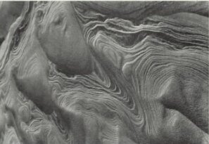
In The Physics of Blown Sand and Desert Dunes, published in 1941, the British geologist Ralph Alger Bagnold describes the Bagnold formula. The equation dictates the speed at which sand grains are transported by the wind; once Neringa’s forests were gone, the dunes mathematically obeyed it. Presumably the people who lived here had no technical term for this, but they understood that their world was shifting at a pace never seen before. There had always been a delicate balance on this narrow bridge of land, only 2.4 miles at its widest part and 1,300 feet at its slenderest, between the forces of the wind, the lagoon on one side, and the waves on the other. The trees, once seen as sacred things, were what held it all together. That balance now tipped and the buried dunes, like giants, woke up and walked.
Fishing settlements on the spit were situated to the east, nestled in the lee of the slopes that sheltered them from the westerly winds that came howling from the sea, like the rage of Naglis. In geologists’ terms they lay under the slip face, the side that wind-blown sand slides down; a dune’s upwind side is known as the stoss. With nothing to stop them, powerful winds pushed the sand up the stoss and down the slip, where it broke on villages in a steady wave. To make things worse, settlements were often built near ‘interdunes,’ valleys that formed convenient corridors from the interior to the sea, which now became open doors for the creeping tide.
Curonian people had always lived one step ahead of the dunes, which, in ancient times, might have moved over the course of centuries. With the trees gone, it must have felt as if time was running faster. Centuries collapsed into decades and decades into years. Floods of sand slid under doors and lapped against windows. In the course of just two hundred years, no fewer than fourteen villages were completely buried, and those that survived only did so by moving location multiple times: dismantling houses, barns, and churches, abandoning what could not be moved, and rebuilding everything farther up or down the coast – only for the same thing to happen a few decades later.
Records kept by the Prussian authorities hint at these abandonments. In 1569 the village of Karvaičiai, around the middle of the spit, consisted of nineteen fishing families and three ‘semi-fisherman families’. By 1641 ‘only a tavern and one fisherman’s house remained.’ In 1825, the writer and pedagogue Reinhold Bernhard Jachmann mentioned Karvaičiai again – presumably in another location, as he noted it had contained up to thirty households four decades previously. Now, he wrote, ‘a single, still-existing tree by the lagoon marks the site of the former village.’ From north to south, and south to north, people migrated with the sands, refugees continually chased from the places they had settled in. The village of Šarkuva moved in 1715, Pilkopa in 1728, Juodkrantė in 1730, and Lotmiškis in 1749, while Nagliai was forced to flee twice, in 1675 and 1732, before it was finally buried for good in 1854. The official term for entombment beneath a dune was ‘sandbound’.
A photograph from 1902 shows this process under way: a wooden house with a reed-thatched roof and a carved gable decoration – a tradition dating back to pagan times, to bring protection and good luck – buried nearly up to its eaves in pillowy white sand. Two men in hats, hands in their pockets, gaze at the camera with the doomed melancholy of everyone in early twentieth-century photographs. Behind them is the sea, and in front, more sand. The effect of the composition is to emphasise their entrapment, caught between a sea of water on one side and a sea of sand on the other, their house made uninhabitable. Only a line of sunken footprints hints at an escape.
Even before the sand-apocalypse, life along this coast was hard. For nine months of the year Curonians fished in the lagoon and for three months at sea, supplementing their fishy diet with the flesh of crows and starlings. Crows in particular were considered a delicacy, eaten salted, smoked or boiled, and locals would entertain foreigners by biting into the necks of dead birds, then taking a swig of vodka. When the flocks migrated south, according to a Russian visitor, people would say regretfully: ‘There go our pigs, flying.’
As their way of life was buried, the eaters of crows flew too. Another Prussian commentator, Ludwig Passarge, wrote in 1868: ‘I don’t know if there will ever be a poet who will be able to describe the last glimpse of those leaving their homes at their former life, their wanderings with their poor belongings, in search of a new place, a new village to build.’ Perhaps he hadn’t read the work of Liudvikas Rėza, born in 1776 and orphaned at the age of six, who’d witnessed the double loss of his parents and his village, in which they’d lived – Karvaičiai, which was finally sandbound in 1797. His poem ‘Graves at Karvaičiai’ mournfully captures that last glimpse:
A mountain brought in by the wind
covered the tops of the oaks.
The graves of our parents on a grey shore,
where the sickle could once be heard.
Rėza also recorded the words of Karvaičiai’s village priest: ‘Let’s pray for those who cut the trees. They did not know what they were doing.’
*
Nida is the largest village on the Curonian Spit today, north of the Parnidis Dune and less than two miles up the road from the Kaliningrad border. One afternoon I drive south, nervously yet curiously, and am slightly relieved to find that the road has been closed long before the checkpoint, anticlimactically blocked by a line of traffic cones. If I was on my own I might have been tempted to go farther, but my mother vetoes this. This trip to Lithuania is, in part, an adventure to mark a significant birthday, but snooping on Russian border guards is the wrong kind of adventure.
The proximity of the Russian Federation casts an ominous shadow here. Beyond the Curonian Lagoon and mainland Kaliningrad is the Suwałki Corridor, a sparsely populated region of the Polish-Lithuanian border. In a quirk of geography, just forty miles of EU territory separates Kaliningrad from Belarus, an obvious target for invasion if Russia were ever to seek to connect its nuclear-armed exclave with its main European ally. This geopolitically vulnerable strip has been called ‘the weakest point in NATO,’ and the war in Ukraine has increased old tensions. There is no obvious military presence in Nida or elsewhere on the spit, but when we climb the Parnidis Dune we find a pair of burly men who do not look like tourists scanning the south with binoculars, where a forested peninsula marks the Russian border. When we greet them, they do not reply. The few local people we ask are tight-lipped about their neighbours in the south. ‘We don’t have anything to do with them,’ says the woman in the national park office. ‘We just leave them alone.’
These are the darkest days of winter, with grey skies and a bitter wind, and Nida – a busy tourist resort in summer – is a ghost town. From the traditional fishermen’s houses, prettily painted in blue, red, and white, to the neighbourhood of modern apartment blocks in which we are staying, people shuffle around in thick coats, their faces to the ground. The only sounds are the hissing of wind and the shift and sigh of slush ice bumping against the frozen shore. Between Nida and the Parnidis Dune lies a wilted meadow called the Valley of Silence – dominated by Neringa’s Chair, a wooden throne built to giantess proportions – which feels like a no man’s land between settlement and sand. In this hushed atmosphere, time itself seems frozen. The village seems to be holding its breath, numbly waiting for whatever might be coming next. Beyond this small sanctuary of calm, with Russian troops stationed so close and Parnidis towering hugely above – 171 feet high, and the largest drifting dune on the spit – it’s hard to escape the sense of inexorable forces on the march, of things that cannot be controlled, of a map that can lurch suddenly underneath your feet.
Nida itself was once located several miles to the south, near where the border is today. The original village was dismantled and moved in 1675, and again in the 1730s, as Parnidis advanced up the coast like an all-consuming slug. Its inhabitants fled with what they could, but many things got left behind – in the 1890s, when the dune moved again, skeletons from the cemetery at the previous settlement were disgorged, emerging as if part-digested from the shifting sands. Another grainy old photograph shows human skulls and bones scattered like driftwood on the beach, while a man poses for the camera.
It is not only landforms that have shifted since Neringa’s forests were felled. Names have also been deformed by the drift of time. What is now Russian Kaliningrad was formerly Prussian (then German) Königsberg, captured by the Red Army in 1945. And the name Parnidis translates as ‘the one that passed through Nida’. As an additional act of conquest, the sand absorbed the name of the settlement it had swallowed.
Another dune to the north of here, which ate the village of Nagliai, is simply called Naglis – the name of the dragon.
*
A weathered wooden boardwalk leads eastwards off the only road, up the long pale slope onto the dragon’s back. From the top of Naglis the view is of the iceberg-cluttered bay, and the grey lagoon, below the slip face of the dune. Turning 180 degrees reveals the Baltic Sea. This sand summit, the guidebooks say, is the only place in Lithuania where you can see the sun rise above one sea (though technically it’s not a sea) and sink into another. Like the Parnidis sundial, it is a place to track the sun, another measure of time.
The region in which Naglis squats is called the Dead (or Grey) Dunes. Both these names suggest lifelessness – ‘grey’ does not usually equate to vitality – but in fact they refer to entirely opposite things. At first glance, the dunes here might appear to be a desert, a barren waste where no life grows, but their distinctive greyish tinge is created by profuse plant life: lichens, mosses, grasses, and sedges stippling the surface. The prints of foxes, deer, and birds crisscross the sand in all directions, evidence of busy life, and far away, two dark shapes raise and lower their long heads as they drift across the land with strange, jerky steps. This is our first sight of elk, grazing on the beach grass.
Strictly protected, with many signs warning against stepping off the path, this desert – far from being dead – is an ecological haven, sheltering endangered species that cannot be found elsewhere. All this life grows here, in part, because of the soil below the sand, the nutrient-rich legacy of a long-buried forest.
This being the Curonian Spit, more than trees are buried here. From Naglis’s west-facing side protrudes a group of wooden crosses carved in traditional folk style, each marked with the name of a different sandbound settlement: Nagliai, Lotmiškis, Kuncai, Gausute, Predine, Karvaičiai. This melancholy monument commemorates what lies beneath – splintered walls and scattered bones, trapped within tonnes of sand.
Now human footprints on the sand have been replaced by animal ones. This dunescape, by turns Dead and Grey, represents both death and life. But ‘Dead’ has another meaning too – one that refers to the dunes themselves. Because these dunes, unlike the giant Parnidis, have stopped moving.
*
On the far side of the moon is a crater called Titius. It was named after Johann Daniel Tietz, a Prussian astronomer who was born in 1729 and taught at the University of Wittenberg, Latinising his surname when he became a professor. Titius is best remembered for the Titius-Bode law, which predicts the distancing between planets in a solar system, but, in true Enlightenment style, he was also a biologist. A contemporary of Carl Linnaeus, the ‘father of taxonomy,’ he wrote a book on the classification of animals, plants, and minerals. Perhaps this is what refocused his eye from stars to sand.
By the mid-eighteenth century, the Curonian Spit was widely acknowledged as a wasteland – what we would recognise now as an ecological disaster. ‘There is probably no sadder place than this anywhere in the world,’ wrote an observer at the time. ‘Just sand and water: not a single tree or a shadow, or a spring from which one could drink fresh water, not a single patch of green grass to break up the uniform whiteness of the sands. I cannot comprehend how people can live here.’
After the end of the Russian occupation in the Seven Years War, which had seen the wholesale pillage of trees, the Prussian government invited suggestions for how to repair the damage. Their concern was partly military – depopulation laid the coastline open to future invasions – but it led to what was surely one of the earliest ecological restoration projects in Europe. In 1768, Titius had published a paper about the Vistula Spit, on the far side of modern Kaliningrad, which proposed the creation of a great sand ridge, stabilised with perennial grasses, to counter the encroachment of dunes. Sören Björn, a Danish-born scientist, adapted the astronomer’s idea; construction of Neringa’s fortification began in 1803.
The ridge was built on the stoss side of the Curonian Spit, facing the westerly wind and the Baltic Sea. Eventually sixty miles long, it was completed over a century, an intergenerational project handed from parents to their children (the first part was finished in 1829 by Björn’s son). Meanwhile, wide-scale reforestation was underway inland. This required levelling the surface of the dunes before the erection of ‘sand traps,’ barriers of pine branches fixed in place with upright stakes, positioned laterally to the direction of the prevailing flow. After these barriers were engulfed, dikes were built on top of them and higher sand traps raised. These defensive fortifications spread for many miles. The stabilised area was then fertilised with horse manure, sown with seedlings, and covered with brushwood to protect it from the wind. The highest dunes were planted accidentally with mountain pine – after a mix-up with the fir seeds that had originally been requested – but the pines proved viable. Their roots crept deep into the sand. Gradually its movement stopped. The dunes began to die.
Sand traps are still scattered across Naglis and Parnidis today, made of the same simple materials that Titius proposed. The ones we see are almost buried, with just the tops of their poles sticking out and smaller branches raked diagonally against the wind-blown sand. They are gaunt, slightly sinister things that recall forgotten wars, with the look of spiked defences for holding back cavalry. Below the whalebacks of the dunes, the spit is covered in forest again – mountain pine, oak, and spruce that shelter elk and wild boar – restored to a landscape of sacred groves, as it was before.
The war against the sand was won. But in some ways it worked too well.
Today it is the dunes themselves that are considered under threat, at risk of being eroded by traipsing humans. Parnidis, the giant that ‘passed through Nida,’ might still technically be ‘alive’ – drifting and wandering by feet or inches every year – but over the last three decades its summit has shrunk by thirty-two feet, and more and more of its slip face is collapsing into the lagoon. In the prevailing Baltic wind, it is only a matter of time before the lagoon fills with sediment, merging the spit with the mainland and destroying the freshwater ecosystem – an inevitable geological process, but one being rapidly accelerated by human actions.
Now efforts are underway to protect the remaining dunes, and much of Parnidis, like the Dead Dunes, is roped off for its own safety. A single footstep can erode tonnes of sand, according to the authorities, each apparently tiny impact magnified hugely in its effect. As a notice near the boardwalk says: ‘Once upon a time giants sculpted the sand, but now it is us who are the giants. The question we must ask now is how we use our power.’
*
That question is now being asked everywhere. For hundreds of years we have treated the world as a giant or dragon to be slain. Now, as geological time speeds up and landscapes shift before our eyes, we find ourselves in a position where even our footsteps can kill.
As I climb crumbling Parnidis, which feels so much like walking in snow, I am reminded of setting forth on another shifting giant. In 2021 I attended a funeral ceremony for Basòdino, a glacier high in the Swiss Alps, which is predicted to melt entirely within the next fifteen years. Walking across its slushy expanse, feeling ice collapse with every step, produced a similar sensation of unease. The surface below me could not be trusted but rather was profoundly unstable, visibly slipping away – ice-melt flowing into the valley as sand now runs into the lagoon, drop by drop and grain by grain. The image of an hourglass is unavoidable. Dune-time, like glacier-time, was once immeasurably slower, its changes so gradual that humans could not perceive them. Now time has telescoped, and those changes take place at human speed. As on Parnidis, what I felt on the Basòdino Glacier was temporal vertigo – bewilderment that something so vast, so apparently fixed in time, could ever disappear.
There are other parallels between dunes and glaciers. The language surrounding both is imbued with a kind of animism: both are said to be alive when they flow and dead when their movement stops. Basòdino, which no longer moves but still contains millions of tonnes of ice, is considered moribund, a ‘dead ice body’. And like the spit’s rampaging dunes, glaciers in the Alps were once capable of extraordinary devastation – people in the valleys below prayed for salvation from their power – but both are intensely vulnerable now, facing their own extinction.
‘Let’s pray for those who cut the trees. They did not know what they were doing,’ said the village priest from Karvaičiai. Do we – in this distant future – know better? We may think we do. But the Curonian Spit is a set of scales that has tipped one way and then the next in response to each clumsy intervention. The question of ‘how we use our power,’ while a call for responsibility, also appeals to modern presumptions of anthropocentric omnipotence. Another question we might ask is how we relearn to be humble.
Near Juodkrantė, a small hill – actually, a reforested dune – forms a popular tourist spot known as the Hill of Witches. Once a pagan pilgrimage site, near the Hollow of Sins with its sacred linden, it is now covered with carvings depicting the giantess Neringa, the dragon Naglis, and other figures from Lithuanian folklore. It is here, one late afternoon in the twilight, that we find red ribbons tied around the branches of oaks – small, unpretentious offerings left by people who still believe that the world is bigger than us, and not the other way round.
We descend from the Hill of Witches before the winter night sets in. Let’s pray for those who cut the trees, and for those who replanted them. Let’s pray for those who are raising the seas. Let’s pray for those who are melting the ice.
On the hourglass of the dunes, the sand keeps trickling.
*
This is our last morning on the spit, so my mother and I search for amber.
Amber keeps another measure of time on this shifting ribbon of sand. Long before Neringa raised the dunes from the sea, pine forests grew along this shore, as they grow again today. Up to forty-eight million years old, fossilised resin still washes up on Lithuania’s beaches, frozen memories of a time when those branches shaded dinosaurs – dragons now sunk beneath the sea, the ancestors, surely, of Naglis.
For thousands of years, this coastline was part of the ancient Amber Road that stretched from the Gulf of Finland to the Adriatic Sea. Curonian people ‘fished’ for amber with nets after the winter storms, which dredged up nuggets from the seabed and scattered them on the beaches. To the poverty-stricken eaters of crows, dispossessed by marauding sands, a large find of amber represented potentially life-changing wealth – but only if they had paid their dues to the ruling authorities. The Teutonic Order imposed the penalty of a particularly painful death on anyone caught collecting the precious resin without a licence.
There are no Teutonic knights around today, so we take our time quietly combing the long, bending Baltic shore, next to what I now recognise as Titius’s great sand ridge. We are not expecting to find anything, but almost immediately I pick up a smooth, translucent pebble that glows like honey when held to the sun. Once our eyes have adjusted, we find another, then another, each one precious and unique – some golden, some white, some molten orange, some flecked with dark impurities that give them the look of planets. Our pockets grow heavy with millions of years, compressed into lucent pebbles. My mother turned one year older this year. She is still strong, but on this trip I have noticed a stumble here and there, a new trepidation of stepping on ice. Far away, glaciers are melting. Before us, sand hisses in the wind. We walk apart and do not speak, stooping to lift these drops of light, checking them against the sun – or the torches of our mobile phones – leaving our footprints in the sand.
Apart from the grinding of the waves, there is only silence.
This piece is also available as audio, narrated by me.